
Recognition of indigenous territories for Nature preservation
Indigenous territories in Indonesia. All photos presented by Kasmita Widodo at Sustainability Week Asia.

INDONESIA – There are an estimated 50–70 million indigenous peoples (IPs) in Indonesia, which amounts to 18–25 per cent of the country’s overall population. Many communities practice traditional wisdom in managing the natural resources of their land, in line with Nature preservation and maintaining environmental balance.
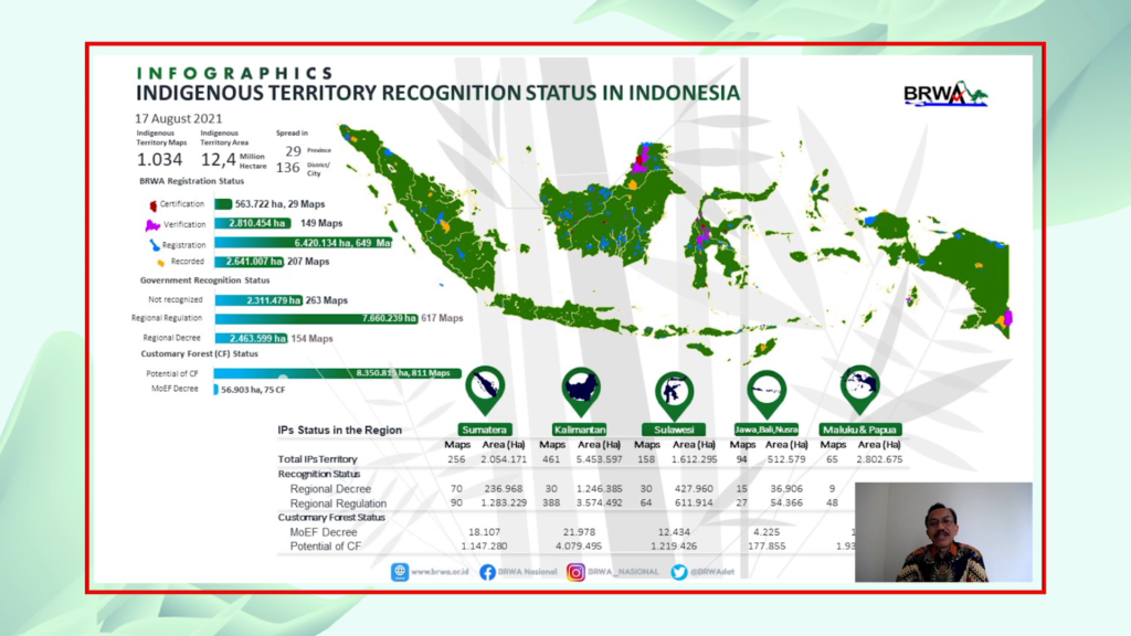
According to latest data in August 2021, there are 12.4 million hectares of indigenous territories in Indonesia, also known as customary areas. Almost half of the territories (5.6 million hectares) include natural forests, and another 878,000 hectares are composed of peat ecosystems. The protection of customary land is an opportunity to support and fulfil Indonesia’s climate commitments and Nationally Determined Contributions.
Sadly, IPs territories’ protection is still a contentious effort. At least 8.5 million hectares of customary areas overlap with permits/concessions for oil and gas companies, palm plantations, and large-scale food estates, due to a lack of legislation that protects IPs rights. The ratification of a bill on IPs (RUU Masyarakat Hukum Adat) has been repeatedly delayed throughout the years, from 2013 to 2020. The bill is now still under discussion by the Indonesian Parliament.
A necessary ongoing step in the protection of IP rights is to a compile a robust database on IP territories. This effort was presented at Sustainability Week Asia, 16 February 2022, by Kasmita Widodo, Head of Badan Registrasi Wilayah Adat (BRWA).
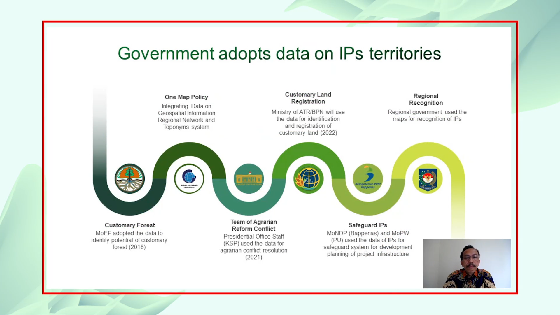
As a non-profit that focuses on the registration and recognition of indigenous peoples’ territories, BRWA has formed and developed an information system for customary territories in Indonesia. Through a voluntary registration mechanism, they collect the spatial and social database of IPs.
Data from various CSOs and communities are standardised, verified and mapped by BRWA, then published on their geoportal. It is published openly to be further integrated by ministries, central and regional government agencies, and other related stakeholders for the planning of infrastructure project and for IPs safeguarding. The ownership of the validated data remains in the hands of IPs, who can use it as a basis to communicate with stakeholders.
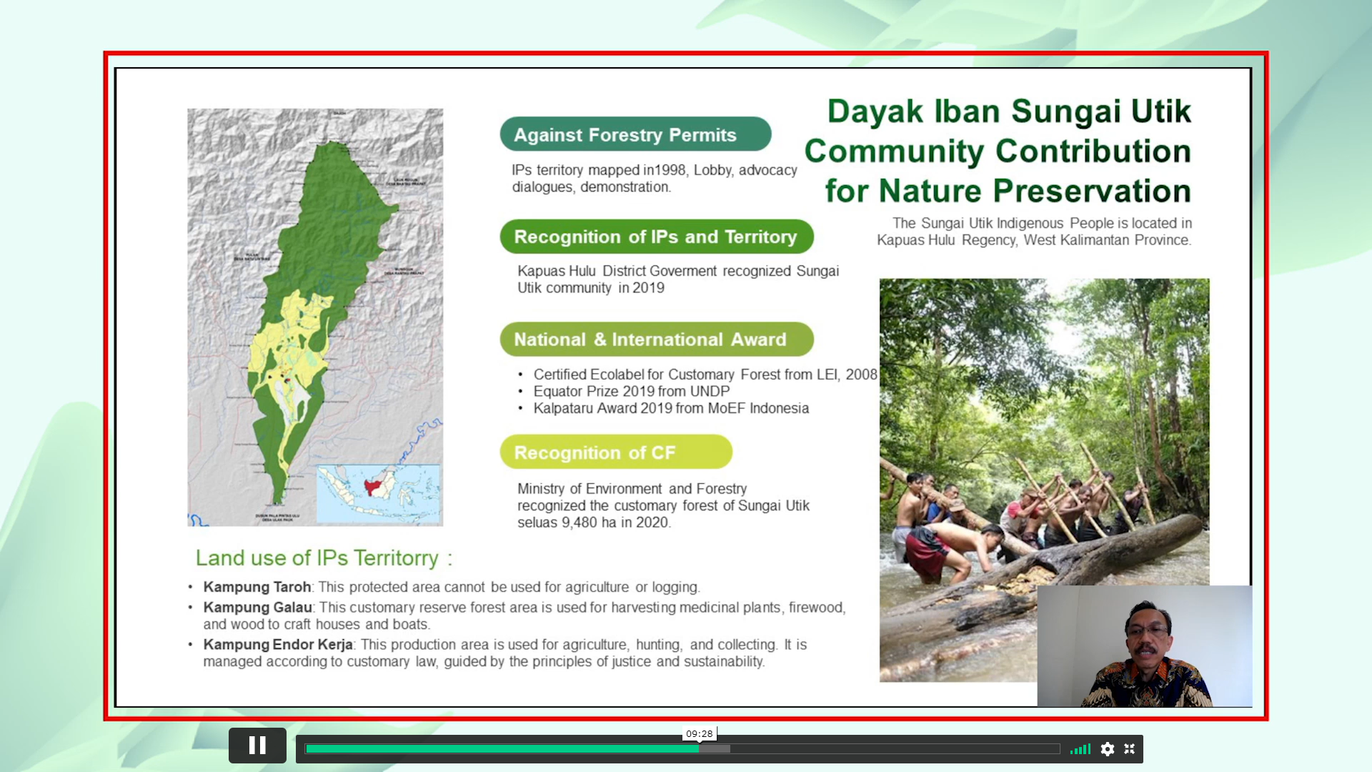
A recent example of successful IPs territory recognition was for the Dayak Iban Sungai Utik Community in Kapuas Hulu Regency, West Kalimantan Province. After decades of mapping since 1998, followed by lobbying, advocacy dialogues and even protests, the District Government of Kapuas Hulu finally recognised the Sungai Utik IPs community in 2019. Their 9,480-hectare customary forest area was further recognised by the Ministry of Environment and Forestry, with three land uses of note.
The area of Kampung Taroh is designated as a protected forest area, where agriculture and logging are prohibited. Meanwhile, Kampung Galau is assigned as a customary reserve forest, where activities of harvesting medicinal plants and using timber for the community’s needs, such as for firewood, houses and boats are permitted. Productive activities such as agriculture and hunting are permitted in the area of Kampung Endor Kerja, in accordance with customary law that is guided by principles of justice and sustainability.
