
Nature & Neighbourhood: A Singapore Snapshot
December 30, 2016
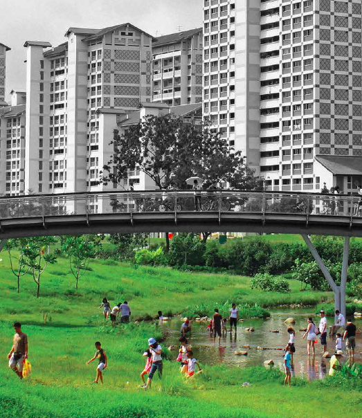
Can landscape and the built environment merge seamlessly as one, especially in dense cities? Eco-puncture is a concept that should be explored and defined in the design of our cities—the break down of concrete barriers within the urban fabric. Green developments should not be confined to stand-alone entities as they also have an impact on the neighbourhood and on the larger public/social spaces. The public could be involved through educational programmes so that they can take pride and ownership in the value of their surroundings—the engagement, support and maintenance plays a part in making urban projects a success. This can be seen in the Active, Beautiful and Clean Waters (ABC Waters) Programme in Singapore, a dynamic initiative that has garnered much success in remodelling the natural and built landscape.
The Public Utilities Board (PUB) launched the ABC Waters Programme in 2006, with the agenda to move Singapore beyond water sufficiency in order to capitalise on the potential of water to enhance the quality of life¹. Singapore now has an extensive drainage network of 32 major rivers, more than 8,000 kilometres of waterways and 17 reservoirs (as at the time of writing). By integrating the landscape, water bodies and the community holistically, this programme aims to create new community spaces and to encourage recreational activities to flourish in and around the waters.
The ABC Waters Programme and the Housing Development Board (HDB) initiatives covered several projects—for example, Sungei Ulu Pandan, Gardens by the Bay and Khoo Teck Puat Hospital—some of which are from the public sector, while others are developed privately. To see how the community has been engaged in these new developments, and the different levels of integration, this article takes a snapshot of three such projects: Punggol Waterway, Bishan-Ang Mo Kio Park and the parks in Pasir Ris.
Connected River: Punngol Waterway
Punggol Waterway Point is a shopping mall that is conveniently located next to the train station and has an outdoor space for leisure activities². Residents and visitors can spend their time in the air-conditioned indoors, and also have the option to step outside to enjoy the fresh air with a view of the river and greenery. Al fresco dining is also an option. Tracks along both sides of the waterway provide an avenue for people to stroll, jog or cycle while taking in the wide expanse of the open area. Benches are placed along part of the waterway in front of the mall for people to relax and soak in the atmosphere. There are boardwalks within the shopping mall that connect and bring visitors to Singapore’s longest man-made waterway³. The mall has skylights for natural ventilation and communal spaces at the base of the skylight (The Cove) invite visitors to sit and enjoy the mini water fountain. It is an excellent place for families to gather—playgrounds keep the children entertained and there is also an outdoor area on level two (The Plaza) that is designed especially for young families.
Taking into consideration that the aim is to allow both residents and visitors alike to enjoy their time here in this landscape promenade, perhaps more could be done to promote this concept. Even during off-peak periods, the place is congested. The space along the river is not quite sufficient for fitness enthusiasts—joggers, cyclists and skaters all seem to vie for a space, and children pose as ‘obstacles’ as they run around playing catch. The tracks could possibly be segregated for different users to minimise the incidence of accidents.
The weather in Singapore is, more often than not, scorching and the air humid. The greenery along the river is planted in a tidy row along the tracks, but the trees, which are quite short and lacking in sufficient foliage, provide next to no shade. Residents and visitors will benefit from sheltered areas at intervals along the tracks. Dust is also brought in by strong gusts of wind blowing over the nearby construction activities for the new housing development, which causes discomfort.
Nature seems to be so near, yet still out of reach. Fences have been built along the river to prevent any danger of people falling into the water, but this also draws a line between public access and nature. Fishing is also prohibited². Thus, the river serves solely as an aesthetic infrastructure for the viewing pleasure of the public, unconnected to the whirlwind of activities happening around it. The river does not seem to be fully integrated with the landscape. There are more concrete spaces in sight than blue and green infrastructure, so much so that what little flora and fauna available seem to pale in significance.
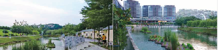
On the other hand, this little area in front of Punggol Waterway Point does lead to Punggol Waterway Park, which offers a wider grassy terrain for activities such as picnics and kite-flying. The park is one of the four that makes up the Riverine Loop, which offers a seamless walkway along the coastline and waterways in the north-east of Singapore³. The waterway also has a floating wetland system and freshwater-tolerant mangroves, developed in-house by HDB, to intensify greenery; enhance the water quality; improve biodiversity; and stabilise the riverbank⁴. This is a good move to bring the sustainability driven solutions into the housing estates, but the river remains out of reach—the public is not able to access or interact with it. That being said, Coney Island, which is connected via this walkway, is a popular spot for outdoor camping and water sports.
Naturalised River: Bishan-Ang Mo Kio Park

The Bishan-Ang Mo Kio Park has more to offer. Spanning 63 hectares and stretching over 3 kilometres⁴, the ABC Waters project at Kallang River at Bishan-Ang Mo Kio Park is a joint collaboration between PUB and the National Parks Board. Nestled in the middle of HDB flats, the park is right at home with the residents and visitors—this oasis offers a green respite that integrates into urban landscape. Nature lovers are in for a treat—coupled with the wide expanse of the terrain, the lush foliage from soaring trees provides fresh air and ample shade.
Mindful of the concept of integrating the park with the river, a redevelopment scheme using soil bioengineering techniques is carried out to transform what used to be a concrete canal into a naturalised river with bioengineered riverbanks⁵. Park users are able to walk along the edge of gently sloped riverbanks, and even get their feet wet for a little fishing. Wildlife like egrets and otters can also be spotted. The park is equipped with three playgrounds; five restaurants; an outdoor spa; and facilities for events and community gatherings. Cleansing biotope and vegetated swales (used in place of concrete drains) facilitate filtration, where the treated water is also supplied to a water playground and contributes to the biodiversity.
Several pathways run across the park, criss-crossing at intersections and splitting into two pathways, which later on merge again as one. Each path is wide enough to accommodate a two-way human traffic, and the numerous paths present alternative routes for users. Other than joggers, cyclists and skaters, many friends and families are also out chatting and laughing on their stroll through the park. The wide grassy terrain also has ample ground for a mini dog park, where many bring their pets out for some exercise. This park has user-friendly facilities, which makes the experience all the more enjoyable.
Water Activities: Parks in Pasir Ris
Situated in the Pasir Ris heartland and just opposite the train station, the Pasir Ris Town Park is a popular space for social gatherings. Supplementing a fitness corner and a playground, a large marine pond also offers visitors fishing⁶ and prawning⁷ activities. Large mature trees provide a cool ambience, and the variety of tropical greenery makes it an ideal setting for strolls or picnics. Hugging the coastal line, Pasir Ris Park⁸ has a more exciting line-up of activities such pony rides, water sports and trails to a mangrove forest where visitors can enjoy bird-watching. These are excellent areas where the public can interact with the landscape.
We Partake, But Also Safeguard
These are three examples of how nature and urban housing areas can be brought together with three different methods of execution. The idea is a great one, but how it is implemented makes a vast difference to the user experience. Questions of comfort and recreational opportunities arise: does it meet the initial aim of preserving the environment, while providing a lifestyle and leisure haven? Are the checklists for sustainability and conservation met? Those that have excelled are the ones that have done so with simplicity and elegance, keeping in mind that first and foremost, minimal damage to the landscape is crucial, but also to respect various aspects of the end-users’ interaction with nature. In reality, not every project has the luxury of land area, like the Bishan-Ang Mo Kio Park for example, for designers to work with.
Advanced technology can be a useful tool to integrate little pockets of nature into the urban network one at a time—systems can be repaired and their functions improved over time.
Drastic changes of the physical landscape might not always be the only method. For example, HDB is exploring the possibility of using a floating wetland system in existing and upcoming towns and estates to hold solar panels on the water surface to harness solar energy⁴. HDB is also collaborating with relevant agencies to bring the freshwater-tolerant mangroves to water bodies in new housing areas, such as the Alkaff Lake in Bidadari and the quarry pond in Tampines North Quarry Park.
What is next?
At the end of the day, it is not only about the seamless merging of the natural and built environments; architects, landscape designers and developers coming on board should take into account community involvement as a crucial element of the landscape design.
This could bring the notion of conservation to the next level, where more people could be involved and take a more active role in preserving the natural landscape. This transforms what is a practical infrastructure into something that opens up more exciting opportunities of engagement with the public and in the process, hopefully a successful community space can be realised.
References
1 https://www.pub.gov.sg/abcwaters/Documents/ABC_DG_2014.pdf
2 https://www.nparks.gov.sg/gardens-parks-and-nature/parks-and-nature-reserves/punggol-waterway-park
3 https://www.straitstimes.com/sites/straitstimes.com/files/ST_IMAGES_WATERSEDGE3.pdf
4 https://www.hdb.gov.sg/cs/infoweb/press-releases/corporate-pr-green-pockets-award-31072016
5 https://www.nparks.gov.sg/gardens-parks-and-nature/parks-and-nature-reserves/bishan—ang-mo-kio-park
6 https://www.nparks.gov.sg/gardens-parks-and-nature/parks-and-nature-reserves/pasir-ris-town-park
7 https://singaporeprawning.blogspot.sg/2009/12/pasirris_10.html
8 https://www.nparks.gov.sg/gardens-parks-and-nature/parks-and-nature-reserves/pasir-ris-park
To read the complete article, get your hardcopy at our online shop/newsstands/major bookstores; subscribe to FuturArc or download the FuturArc App to read the issues.
Previously Published Commentary
Contact us at https://www.futurarc.com/contact-us for older commentaries.